

Florida Tech Operations and Planning
The Department of Security website has information regarding hurricane preparedness and other campus security initiatives.
- Florida Tech Emergency Plans
- Emergency Information Line: 888-820-4636 (recorded updates)
- Safety Alerts - Rave
- National Hurricane Center
- The National Hurricane Center (NHC) is the official source for predictions, advisories, warnings, satellite images and analysis of hazardous tropical weather
- Federal Emergency Management Agency (FEMA)
- The "Ready" website has information to help you prepare for disasters. This includes putting together an emergency plan and emergency supply kit
- Florida Division of Emergency Management (FDEM)
- FDEM provides pre and post-event information and planning tools on its website
- City of Melbourne
- Visit the City of Melbourne's Website
Your initial preparedness contributes significantly to Florida Tech's ability to prepare for, respond to and recover from any storm - minor or major. The information contained in this guide is intended to help you prepare.
Additional hurricane preparedness information is available from the FEMA website as well as other resources listed in this guide.
This guide can serve as your ready reference for the specific activities that are likely to occur should a tropical storm or hurricane threaten the Melbourne and Brevard County area. Hurricane season encompasses June through November with August to October being the most active months. Prior to this time, it is important to prepare by maintaining a disaster supply kit, having a plan in place, and keeping track of the weather and university communications.
Hurricane season begins on June 1 and runs through Nov. 30
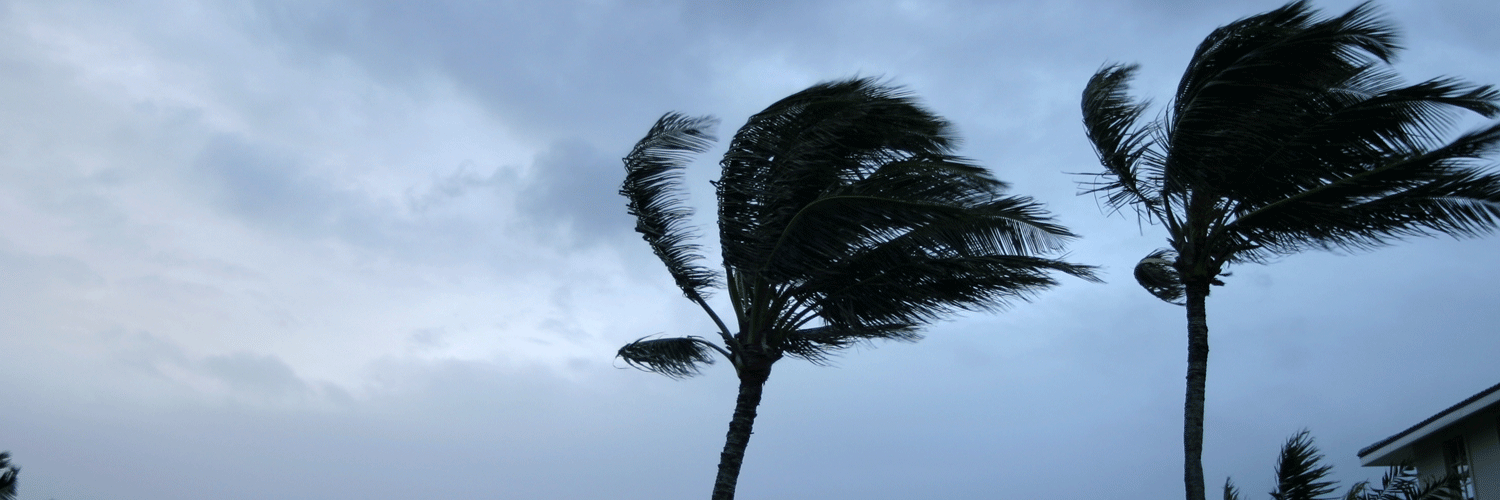
Tropical depressions are low-pressure storm systems with maximum sustained surface winds of 38 mph or less. Tropical storms have maximum sustained surface winds of 39-73 mph. Hurricanes are large, spiraling tropical cyclones with wind speeds of at least 74 mph and can elevate to over 160 mph and unleash more than 2.4 trillion gallons of rain per day. 40% of the hurricanes that occur in the U.S. hit Florida, so it's critical for the Florida Tech community to be alert and prepared. Remember, tropical storms and hurricanes can intensify and change direction within hours.
The National Weather Service (NWS) and National Hurricane Center (NHC) release information regarding storm strength, forward speed, timing, and landfall probabilities. States, communities, local weather forecasters and others rely on this information to decide when to take preparedness actions and to make evacuation recommendations and decisions. Florida Tech monitors weather forecasts from the NWS and NHC and receives situational reports from both the Florida Division of Emergency Management and the Brevard County Office of Emergency Management regarding actions to take for our community.
Watch vs. Warning
Hurricane watches and warnings are issued by the National Hurricane Center; these designations correspond to hours before the estimated time of arrival of gale force or hurricane force winds, and the likelihood the event is to occur.
A watch lets you know that weather conditions are favorable for a hazard to occur. Watches are issued 48 hours in advance of the anticipated onset of tropical storm force winds. During a weather watch, gather awareness of the specific threat and prepare for action - monitor the weather to find out if severe weather conditions have deteriorated and discuss your protective action plans with your family.
A warning requires immediate action. Warnings are issued 36 hours in advance of the anticipated onset of tropical storm force winds. This means a weather hazard is imminent - it is either occurring (for example, a tornado has been spotted) - or is about to occur at any moment. It is important to act during a weather warning.
Watches and warnings associated with tropical weather are:
- Tropical Storm Watch - Tropical storm conditions are possible within the specified area
- Hurricane Watch - Hurricane Conditions are possible within the specified area
- Tropical Storm Warning - An announcement that tropical storm conditions are expected within the specified area
- Hurricane Warning - Hurricane conditions are expected within the specified area
- Extreme Wind Warning - Extreme sustained winds of a major hurricane (115 mph or greater), usually associate with the eyewall, are expected to begin within the hour
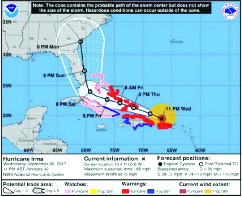
Forecast Cone
The National Hurricane Center (NHC) uses models and historical data to predict the path of the center of tropical storms and the eye of the hurricane. The forecast cone is a projected path of the hurricane's center within five days. It is important to remember that the effects of a tropical cyclone can be experienced well away from the center of the storm and well outside the forecast cone. The actual path of the storm's center does not always stay within the cone.
The line in the center is typically the best estimated path of the threatening storm and can have a margin of error up to 99 miles during a 48-hour outlook. Community members living in any area outside the cone should prepare for some affects from the storm.
Wind Scale
The Saffir-Simpson Hurricane Wind Scale is a 1-5 rating based on a hurricane's sustained wind speed. Hurricanes reaching category 3 and higher are considered "major hurricanes" because of their potential for significant loss of life and damage. However, Category 1 and 2 storms are still dangerous and require protective and preparation measures.
| Category | Sustained Winds |
|---|---|
| 1 | 74-95 MPH |
| 2 | 96-110 MPH |
| 3 (Major) | 111-129 MPH |
| 4 (Major) | 130-156 MPH |
| 5 (Major) | 157 MPH or higher |
Preparing for a Hurricane
Class Cancellations and Campus Closures/Evacuations
Communications regarding class cancellations, campus closures, evacuations and re-openings will be posted to the main Florida Tech website and sent to students and employees via phone and email as a Florida Tech Rave Alert. It is important to monitor official Florida Tech communications during emergencies as conditions can change rapidly. Continue to check your Florida Tech email and the Florida Tech website for information. Students and employees should also verify they are enrolled in the Emergency Alert System - Rave Alert.
Should it be necessary to evacuate the campus, faculty members will communicate with students regarding assignments and, if possible, remain in touch with students via email. Prior to any evacuation, resident students will meet with the resident assistant (RA) to review procedures.
Make a Plan
You should begin making a general evacuation plan now. As the storm nears, communicate your evacuation plan to family, friends and co-workers so someone knows where you are. If you change your plan, make sure to communicate the change. Students should have conversations with their families to review their hurricane plans and discuss where they will go in the event the campus is evacuated.
- Visit the Florida Disaster website for assistance developing an emergency plan
- Visit the Florida Disaster website to find evacuation zones and the FEMA website to find flood zones by address
Disaster Supply Kit
It is important to maintain a disaster supply kit year-round with enough supplies to last 72 hours. Supply kits should include, but are not limited to:
- Water, one gallon per person, per day
- Nonperishable food
- Manual can opener
- Battery-powered or hand crank AM/FM radio
- NOAA weather radio with extra batteries
- Flashlight with extra batteries
- First aid kit
- Personal hygiene items
- Blanket
- Extra clothes and comfortable, closed-toe walking shoes
- Medications
- Cash
Visit the Ready website for more information on putting together a disaster supply kit
Residence Evacuation Preparation
Take your most important belongings, valuables and personal documents with you. Students should remember to take course materials with them.
When evacuating, completely empty and unplug your refrigerator and wrap towels around the base to absorb water due to defrosting. Unplug all power cords before leaving. Close and lock your windows tightly. Do not tape your windows. Move any items that may be damaged by water off the floor and cover electronic items with plastic. Remove any trash and lock the door.
Pets/ESAs
Do not leave your animals behind. Prepare a safe location for your animals - this may be with you, with a friend, in a kennel in a non-evacuation zone or in a pet-friendly shelter. Pet-friendly shelters will only accept dogs and cats with up-to-date vaccinations and registration. Visit Brevard County's emergency management website for more information.
Pet Disaster Supplies:
- Proper ID collar with current rabies vaccination
- Vaccination paperwork
- Ample food, water, treats, cleaning supplies and litter, if necessary
- Crate and leash. Cats need a crate large enough to contain litter, food and water
- Any required medication
Transportation
If leaving the area by car, fill your gas tank and prepare your vehicle for travel as the storm approaches. Gas supplies are often scarce, and prices may increase due to high demand during an evacuation. If your vehicle remains on campus, move it to the designated locations. Ensure that your valid Florida Tech parking decal is properly displayed so you can be identified as the owner.
If you choose to evacuate by plane, be aware that returning to campus may be challenging due to fuel rationing, demand for flights and overwhelmed airports.
You should plan for two evacuation locations: (1) in your county or within close driving distance of your residence, and (2) a non-local location, away from the storm's path. Consider developing a plan to share driving and lodging expenses with friends or family.
Evacuation Shelters
Shelter space is often limited, and it is difficult to safeguard your personal belongings. Evacuation shelters do not have generators and offer no services other than a basic food provision, water and limited amount of floor space per person. There are no cots, pillows or blankets provided. You should treat shelters as a refuge of last resort. Attempt to stay with friends and family in non-evacuation zones or other lodging alternatives.
Shelters are activated during hurricanes by the county emergency management officials. Pre-registration is required for special needs shelters and may also be required for pet-friendly shelters. Contact the county emergency management agency to register.
If Florida Tech's campus is required to evacuate, residential students will be provided information regarding shelter plans through the Office of Residence Life.
Returning to Campus
The severity and intensity of damage caused by the storm on roadways, transportation routes and campus will contribute to Florida Tech's decision to reoccupy campus. Valid and current identification such as a driver's license, Florida Tech ID and proof of residence may be required at checkpoints for evacuees to return to the area.
All students, faculty and staff should continually monitor the Florida Tech website and email communications for up-to-date information regarding campus operations. The university will make all attempts to reopen and resume classes as quickly as possible but must make every effort to provide a safe environment for the Florida Tech community to return.
Hurricane Disaster Checklist
- Medications
- Pillow, blanket, air mattress and/or cot
- Passports and hard-to-replace documents in secure plastic bag
- Cash
- Personal and student identification
- Clothing for 5 to 7 days, including socks and sturdy shoes
- Personal hygiene items
- Quiet games, reading material, music player, headphones and batteries
- Flashlight and extra batteries
- Keys to your car and residence
- First aid kit
- Bottled water, snacks and nonperishable nutritious food
- Can opener
- Food for specialty dietary needs
- Mask/facial coverings
- Gloves
- Hand sanitizer
- Battery-powered or hand crank AM/FM radio
- NOAA Weather radio with extra batteries