Mission

Our mission is to integrate oceanography, marine biology, ocean engineering, environmental science, ecology, meteorology, remote sensing, sustainability, and related academic endeavors into an interdisciplinary search for solutions to vital contemporary issues through education, research and service. 

Ocean Engineering

TEC-V ROV


Team Leader(s)
Stephen Coster

Team Member(s)
Stephen Coster, Henry Hill, Gabor Papp, Michael Dowling

Faculty Advisor
Dr. Stephen Wood


TEC-V ROV  File Download
Project Summary
TEC-V (Topographic Exploration Cave Vehicle) is a remotely operated vehicle (ROV) designed for the underwater exploration of enclosed environments, such as caves, shipwrecks, port structures, and large-scale pipelines. TEC-V’s design incorporates aspects that allow the vehicle to operate in these conditions, including a reduced, streamlined profile and five degrees of freedom to improve maneuverability. The vehicle employs a carbon fiber fairing to enclose the internal components, the design of which emphasizes favorable hydrodynamic properties to increase control. While operating in these enclosed areas, TEC-V utilizes a side-scan sonar unit to scan its surroundings and obtain a two-dimensional plane of data. As the vehicle performs a roll maneuver, a ring of data is collected. Data processing allows subsequent scans to be stitched together to develop a continuous, three-dimensional map. With the successful mapping of these enclosed areas, the project aims to develop a model to intuitively visualize and manipulate a three-dimensional environment. These models will be useful to obtain detailed imaging of environments where human divers cannot reach or areas where the risk to human life is too great. Scanning marine environments such as underwater caves, sinkholes, reefs, or environments under a layer of ice will be beneficial to the fields of geology, biology, and oceanography to increase understanding of these areas. Inspection of shipwrecks, oil platforms, pipelines, and port structures may yield initial condition assessments to specify areas in need of repair and reduce danger to human divers.


Project Objective
The goals of the TEC-V project were to develop a modular, cost-effective platform for confined underwater environment exploration. After completing the design; hydrostatic, and hydrodynamic analyses were performed on the vehicle to achieve the desired properties to satisfy mission objectives. Once vehicle dynamics were optimized, a sonar unit was integrated and the mapping procedure was tested for future development.

Manufacturing Design Methods
TEC-V’s frame comprises of starboard rails, 3D-printed brackets/braces, and 316 stainless steel hardware. The 3D printed parts were printed out of PETG filament which is more rigid and water resistant than other available filaments. For the fairing, a negative mold was 3D-printed for manufacture. The mold was sealed in a protective vacuum bag and the carbon fiber was hand-laminated into the mold. A final vacuum bag was applied over the part and left to cure. Post-processing consisted of sanding, painting, and clear coating the shells.


Future Works
The TEC-V platform offers a base-level system to facilitate the eventual application of autonomy. Through the integration of additional sensors and programming beyond the initial scope of this project, TEC-V has the potential for tether-less operation and data processing. The use of advanced machine learning and artificial intelligence may be required for progression. Additional software development focusing on filtering and displaying sonar data would further enhance the utility and accessibility of the platform.


Acknowledgement
The team would like to express thanks to the students in the Underwater Technology Lab (UTL) for their support and guidance. Also a special thanks to Dr. Ronnal Reichard and the team at Structural Composites, Inc. for their expertise and donations to this project.


Mechanatee


Team Leader(s)
James Lacey

Team Member(s)
Cannon Bogar, Aidan Calenda, Jackson Clendenin, James Lacey, Laura Mace, Alexandra Staros, Eden Stroman, Jacob Warner

Faculty Advisor
Stephen Wood

Secondary Faculty Advisor
Philip Chan


Mechanatee  File Download
Project Summary
The Mechanatee is a Remotely - Operated Vehicle (ROV) meant to discreetly survey Manatee populations in the Indian River Lagoon without disrupting their natural behaviors. The project features a mechanical build of a manatee tail and computer vision software.


Project Objective
The Mechanatee project aims to create a non-invasive underwater research tool capable of studying marine animals in their habitats without disturbing their natural state. Traditional ROVs lack the organic motion and shapes necessary to blend into natural environments, and few can operate effectively in shallow, estuarine ecosystems. The project aims to enhance conservation efforts by collecting data in sensitive coastal areas while limiting disturbances caused by traditional data collection methods.

Manufacturing Design Methods
The Mechanatee tail design has undergone two major design iterations. Prototype-1 used a ball-and-socket design acting as vertebrae joints, actuated by cables. Prototype-2 follows a more simplified design using a linear actuator and servo motor for more controlled and biomimetic motion at the waist and fluke. The two main modules of the tail were constructed from heat-formed HDPE, aluminum, and HDPE reinforced silicone parts while following a semi-monocoque aircraft fuselage concept to create the tail of a West Indian Manatee.

Specification
The project's specifications encompass a 1.5 meter operating depth, the fluke surface area of around 0.1 m², and functioning in the Indian River Lagoon’s 1010kg/m³ water density. Our linear actuator creates 2 kN at 24VDC, along with the tail being designed with modular integration for future work on the Mechanatee. The materials were selected with careful consideration of environmental conditions, using non toxic materials that are also resilient in a marine environment. In regards to the software, the software was prepared using Facebook's Detectron2 with Mask R-CNN as a backbone model. The model was specifically tuned to recognize scarring, active injuries, and emaciation of manatees.

Analysis
The first prototype revealed restrictions in force efficiency and control, which led us to Prototype-2. A careful examination of the tail motion, and material performance illuminated the new designs' improved performance. Shear stress, torque, and pressure calculations directed the structural modeling. After buoyancy testing, we concluded that additional buoyancy tactics will need to be implemented in order to counteract 23.4 Newtons of downward force.

Future Works
Future developments will aim to provide a secondary propulsion system, flippers, which will allow for control and steering. Adding a system for remote operation and integrating water quality sensors and cameras will allow the Mechanatee to swim into remote waters and record data without disrupting the natural state. The team also hopes that, in the future, BROV technology will expand into areas like ecotourism and theme park applications.


Acknowledgement
The Mechanatee team would like to thank Florida Tech and Dr. Stephen Wood for their continuous support and mentorship. Special thanks to the Harris Student Design Center staff, Underwater Technology Lab advisors, and all who contributed time, resources, and expertise.


Marine Sciences

Identifying the Presence of Quorum Sensing-like Behavior in the Single Celled Alga Chlamydomonas nivalis

Project Summary
Density dependent phenotypic switching in unicellular organisms is generically classified as Quorum sensing (QS). This phenotypic switch controls a wide assortment of phenotypes such as motility, virulence, biofilm formation, and bioluminescence across multiple genera and domains of life. This phenomenon has been observed in the model unicellular eukaryote, Chlamydomonas reinhardtii as well as the closely related Chlamydomonas moewussi in which QS increases swimming speed at higher cell densities. This raises the important question of whether this phenomenon is conserved throughout this cosmopolitan genus. Another species of Chlamydomonas, the snow alga Chlamydomonas nivalis, is found in significantly different environments from either C. reinhardtii or C. moewussi but is also reported to be motile. Hypothesizing that this motile species will similarly be regulated by QS, I have characterized the motility and growth of C. nivalis in comparison to C. reinhardtii. I found that C. nivalis takes over four times as long to reach a high cellular density in comparison to C. reinhardtii in 20 C. In addition, C. nivalis also presents largely non-motile in observation under a light microscope. However, in a phototaxis experiment, I found that C. nivalis still is capable of phototaxis and therefore moves much slower than C. reinhardtii at 20 C. I hypothesize that the QS system presents phenotypically different in C. nivalis than in C. reinhardtii due to the ecophysiological differences between these two different members of the Chlamydomonas genus.


Assessing the Correlation between Chlorophyll a Levels in Biofilm and the Water Column


Team Leader(s)
Madison Tate

Team Member(s)
Madison Tate

Faculty Advisor
Dr. Kelli Z. Hunsucker

Secondary Faculty Advisor
Dr. Austin L. Fox


Assessing the Correlation between Chlorophyll a Levels in Biofilm and the Water Column  File Download
Project Summary
Assessing the correlation between chlorophyll a levels in biofilm and the water column in the Indian River Lagoon. Madison F. Tate and Kelli Z. Hunsucker. Center for Corrosion and Biofouling Control, Florida Institute of Technology, Melbourne, FL, United States. Biofilm, sometimes referred to as microfouling, forms when microorganisms such as bacteria and algae adhere to submerged surfaces, forming a matrix that ensures survival even in harsh environmental conditions. While biofilm is a natural process, it creates significant challenges, especially in the maritime industry, where its accumulation on ship hulls increases drag and fuel consumption. This causes an increase in the cost of operation which totals millions of dollars in extra expenses for large organizations such as the Navy. Despite continuing advancements in antifouling coatings, there is limited research on how environmental parameters influence biofilm development, making prevention difficult. This study investigates the correlation between chlorophyll a levels in the water column and adjacent biofilm communities to assess whether water conditions can predict biofilm growth. Biofilms were cultivated on panels placed within a flow channel in an estuarine environment. Water and biofilm samples were collected over eight rounds of panel deployments, spanning several months to capture seasonal variability. For each of the biofilm and water samples, chlorophyll a was measured using a plate reader protocol and diatom species were identified by performing cell counts. This research aims to develop a framework for predicting biofilm formation based on water parameters, such as chlorophyll a, aiding in the development of more effective or targeted antifouling strategies. Keywords Biofilm, chlorophyll, microfouling, antifouling strategies, Indian River Lagoon


Acknowledgement
I would like to thank both Dr. Kelli Z. Hunsucker as well as Dr. Austin L. Fox for helping plan and carry out this project. I would also like to thank ORCA for providing water quality parameters to perform the analysis. This work was done on an ONR funded research platform.


Response of Coral-Reef Fish to Fishing Pressure


Team Leader(s)
Allyah Vega

Team Member(s)
Allyah Vega

Faculty Advisor
Dr. Ralph G. Turingan


Response of Coral-Reef Fish to Fishing Pressure  File Download
Project Summary
Marine protected areas (MPAs) are subsets of traditional fishing grounds typically closed to fishing, serving as a key component of fisheries management and sustainability programs worldwide. It is hypothesized that MPAs help sustain exploited stocks by one or both mechanisms: (1) larvae spawned in the MPAs recruit into the Adjacent Fished Reefs (AFRs), and (2) juveniles and adults migrate from MPAs into AFRs. Evidence shows that (1) while fish density is higher in MPAs than in AFRs during a specific sampling period, overall reef-wide fish density either increases or remains stable over time, and (2) large-bodied fish become more abundant in AFRs as time progresses. These results suggest that MPAs promote beneficial shifts in fish population structure across the entire reef systems after a few years of protection rather than simply maintaining stable populations within their borders. This study used six species native to the Zambales, Phillips (Acanthurus nigrofuscus, Ctenochaetus binotatus, Ctenochaetus striatus, Plectroglyphidodon lacrymatus, Parupeneus multifasciatus, and Zebrasoma scopas) to examine six metrics of fish performance (age, body weight in grams (g), body weight without stomach (g), condition factor (K), gonad weight (g), and standard length in centimeters (cm)) to provide further evidence that MPAs benefit AFRs through spillover mechanisms. It was found that in all measured species, age, body weight in grams (g), body weight without stomach (g), gonad weight (g), and standard length in centimeters (cm) are statistically different between MPA and AFR. However, the condition factor, a proxy for fish health, was statistically similar between MPAs and AFRs. These findings suggest that the spillover mechanisms that stem from MPAs serve as refuges where fish can grow larger and reproduce more effectively, leading to the export of larvae and adults to surrounding areas. The observed differences in traits, such as size and reproductive indicators, strengthen this conclusion. The condition factor, which reflects fish health by relating weight to length, is similar in both locations and suggests that fish outside the MPAs are not unhealthy. This implies that the spillover may help support fish populations in AFRs without compromising fish quality. Essentially, MPAs enable sustainable fishing while maintaining stable populations capable of replenishing themselves.


Analysis
This meta-analysis utilized R Studio to analyze the dataset generated by Dr. Robert Fidler's research in the Philippines.


Acknowledgement
All data collection was done by Dr. Robert Fidler and the Fulbright Program.


Ontogeny of Microbial Community Structure in Different Seagrass Growing Substrates


Team Leader(s)
Ranamae Malubay

Team Member(s)
Ranamae Malubay, Carmen Braun, Jack Denvir, Nicole Katz, Jenisse Louis, Sajeda Shloub

Faculty Advisor
Dr. Ralph Turingan and Dr. Toufiq Reza


Ontogeny of Microbial Community Structure in Different Seagrass Growing Substrates   File Download
Project Summary
Florida’s Indian River Lagoon is one of the most biologically and ecologically diverse ecosystems in the U.S. Seagrass meadows are essential habitats as it contributes to more than $55.4 billion annually to Florida’s economy. Seagrasses are essential to coastal ecosystems, providing habitat, improving water quality, and supporting biodiversity. Unfortunately, at least 52% of the seagrass meadows disappeared from IRL since 2010, resulting in a massive decline of economically and ecologically important species. This project introduces biochar application to IRL sediment to accelerate the restoration of seagrass communities in the IRL and ultimately restore, revitalize, and sustain a healthy seagrass community in the IRL. This research explores how different sediment types—natural sediments, artificial substrates, and biochar-enhanced media—influence the ontogeny of microbial community structure in early-stage seagrass environments. Drawing from existing literature, we hypothesize that biochar-amended substrates will promote greater microbial diversity and stability due to their porous structure, high surface area, and nutrient-retentive properties. Wang et al. (2021) demonstrated that low-dose biochar applications in submerged sediment systems improved water quality and supported macrophyte growth, while Lehmann et al. (2017) highlighted its benefits in enhancing microbial activity in terrestrial soils. By analyzing microbial community structure over time, this study seeks to understand how substrate composition influences microbial succession and how this, in turn, may support seagrass establishment and ecosystem restoration efforts.


Future Works
This project will advance laboratory studies to optimize biochar-amended substrates for restoring three critical seagrass species (Halodule wrightii, Syringodium filiforme, and Thalassia testudinum) in the Indian River Lagoon. Controlled experiments will test biochar-sediment mixtures in 30-day growth trials using lagoon water and sediments, with rigorous monitoring of rhizome elongation, biomass accumulation, photosynthetic efficiency, and microbial community shifts. Sediment sulfide levels and nutrient dynamics will be analyzed to assess biochar’s role in reducing toxicity and enhancing nutrient cycling. Statistical models (ANOVA, post-hoc comparisons) will identify species-specific biochar ratios that maximize growth and ecological benefits. These findings will inform subsequent 90-day raceway trials to evaluate scalability under simulated field conditions. Successful results could transform seagrass restoration by providing a science-backed protocol for stabilizing degraded sediments, accelerating nursery propagation, and improving transplant survival rates. Longer-term implications include the potential integration of biochar into large-scale restoration efforts, cost-effective habitat recovery strategies, and insights into microbial-seagrass relationships that enhance resilience to environmental stressors like eutrophication.


Acknowledgement
We thank Dr. Toufiq Reza and his students for introducing the concept of biochar to the Turingan Fishlab/Aqualab.


Climate Change and the Biogeography of a Critical Component of Coral Reefs


Team Leader(s)
Summer Smith

Team Member(s)
Summer Smith

Faculty Advisor
Dr. Richard Aronson


Climate Change and the Biogeography of a Critical Component of Coral Reefs  File Download
Project Summary
Coral reef ecosystems are facing shifts in community composition because of climate change. Species with higher environmental tolerances have greater survivability rates through temperature anomalies. Palythoa caribaeorum is an encrusting colonial anemone with high environmental tolerance that can overgrow and outcompete neighboring benthic species, such as corals and sponges. This study aimed to plot and identify the distribution of P. caribaeorum along Florida’s coast and project its distribution in 2100 based on climatic models. The present-day species-distribution model predicts a high probability of P. caribaeorum along the Florida Keys Reef Tract (FKRT), with moderate suitability extending along the east and west coasts of Florida. Within the FKRT, the current P. caribaeorum abundance is highest in the Middle Keys. Projections under RCP 4.5 and 6.0 scenarios show a decline in suitable habitat throughout the FKRT and along the Florida coast, whereas the RCP 8.5 model indicates a substantial loss of habitat suitability across the entire region. As environmental conditions become less favorable, we should expect a decline in coral abundance throughout the FKRT, followed by a shift toward zoanthid- and macroalgal-dominated communities, as they have higher environmental tolerances.


Project Objective
This study aimed to plot and identify the distribution of P. caribaeorum along Florida’s coast and project its distribution in the year 2100 based on climatic models.

Manufacturing Design Methods
Occurrence data were obtained from the Coral Reef Evaluation and Monitoring Project (CREMP) dataset. Environmental variable layers, including sea surface temperature, salinity, and chlorophyll-a concentration, were sourced from the Bio-ORACLE database. Predictive RCP layers were obtained through Bio-ORACLE. Mapping and statistical analyses were performed in RStudio.


Future Works
This research may be of consideration in future management and policy decisions regarding Florida’s reefs.


Genetic Insight on Two Elasmobranch Species in Sri Lanka


Team Leader(s)
Dylan Gore

Team Member(s)
Kenna Peters, Buddhi Pathirana, Annais Muschett-Bonilla, Christine Sarkis, and Sahan Thilakaratna

Faculty Advisor
Toby Daly-Engel


Genetic Insight on Two Elasmobranch Species in Sri Lanka  File Download
Project Summary
Marine predators play a crucial role in shaping ecosystem recovery, with their ability to influence interactions at every level of the food web. Predators also function as marine sentinel species, the first organisms to be impacted when a habitat is disturbed, so their status can provide direct insight into ecosystem health. Elasmobranch fishes (sharks and rays) are important keystone predators in nearly every aquatic ecosystem, capable of maintaining physical connections between distal habitats. Over the past 50 years, elasmobranch abundance has dropped 70% from overfishing and climate change, increasing conservation concern. However, many populations throughout the world are known to be Data Deficient, meaning that there is insufficient information upon which to base management decisions. To remedy this, we aimed to describe patterns of genetic structure and diversity in populations of two common elasmobranchs from Sri Lanka, the tiger shark Galeocerdo cuvier and the whipray Brevitrygon sp. Sri Lanka is a designated tropical global biodiversity hotspot island in the Indian Ocean, and one of the top 20 documented shark fishing countries. Approximately 50 tissue samples of each species were collected from four fish markets on the west coast. From these, we sequenced the mitochondrial genes ND2 and CO1, and used Bayesian inference to construct phylogenetic trees along with outgroups downloaded from GenBank. For G. cuvier, our results showed low diversity and strong evidence of connectivity between regions, with haplotypes shared between Sri Lankan sharks and those elsewhere in the Indian Ocean, as well as the Indo-Pacific and West Atlantic. For Brevitrygon sp., phylogenetic analyses confirmed this species to be Brevitrygon imbricata, as Sri Lankan samples grouped together with known B. imbricata and away from all other species with a high degree of confidence. Taken together, these results indicate that elasmobranchs sampled from the fish markets of Sri Lanka are connected by gene flow to populations in other regions, suggesting that they may resist depletion better than more isolated groups.


Acknowledgement
This study was conducted in collaboration with the nonprofit organization Minorities in Shark Science (MISS), through its Integrated Coordinated Open Networked Inclusive Conservation (ICONIC) Oceans initiative. Thank you to everyone in the Daly-Engel Lab for support. This work was funded by Re:Wild and The Campbell Foundation, and by a Provost Seed Grant from the Florida Institute of Technology.


Iron (III) and Grain Size in the IRL


Team Leader(s)
Kyle Dobberman

Team Member(s)
Kyle Dobberman

Faculty Advisor
Dr. Austin Fox


Iron (III) and Grain Size in the IRL  File Download
Project Summary
Iron is an element that is necessary for life, but due to its abundance, it isn't quite considered bio-limiting. However, with changing water temperatures, salinity, acidity, and anthropogenic changes connected to climate change, it is necessary to monitor iron levels alongside other nutrients such as nitrogen and phosphorus in sediments. This project compares grain size, specifically fine grains like silt and clay, to the Iron (III) content within the same sediments. Due to the high surface area to volume ratio and their overall negative charge, they are ideal for sorbing larger levels of positively charged ions in the water, such as iron. Using several sampling sites from across the Indian River Lagoon, then using grain size analysis as well as iron extraction using AAS flame methods, it was found that in a direct comparison, with a p-value of


Hidden Hammerheads: Discovering Genetic Markers of Differentiation and Hybridization in Cryptic Shark Species


Team Leader(s)
Kieran Stein

Team Member(s)
Kieran Stein, Rachel Schweppe, Abby Hesterhagen, Michelle Gargiulo

Faculty Advisor
Dr. Toby Daly-Engel


Hidden Hammerheads: Discovering Genetic Markers of Differentiation and Hybridization in Cryptic Shark Species  File Download
Project Summary
Scalloped hammerheads (Sphyrna lewini) are a globally endangered species whose life history traits make them vulnerable to fishing pressure. Conservation of the species has been complicated by the discovery of the cryptic Carolina hammerhead (Sphyrna gilberti), which overlaps in range and closely resembles S. lewini 3. The only consistent morphological difference, vertebrae count, is lethal to assess. Few studies have jointly assessed S. gilberti and S. lewini populations, and only one has previously investigated potential hybridization. This study is the first to develop a method for determining hybridization using a combination of the nuclear gene ITS2 and the mitochondrial control region (mtDNA). Because mtDNA is maternally inherited and nuclear DNA is inherited from both parents, a mismatch between them, known as mitonuclear discordance, can reveal hybridization. If the mtDNA indicates one species while the nuclear DNA indicates another, it suggests the individual had parents of different species and is therefore a hybrid. These tools provide an accessible, nonlethal method for detecting hybridization in cryptic elasmobranchs (sharks, skates, and rays), which is crucial for informing effective conservation strategies.


Acknowledgement
Special thanks to Dr. James Sulikowski and the amazing people in the Daly-Engel lab for making this project possible.


Development of an eDNA Protocol for Non-Invasive Detection of Atlantic Tarpon


Team Member(s)
Paolo Soto

Faculty Advisor
Dr. Toby Daly-Engel, Dr. Jeff Eble


Development of an eDNA Protocol for Non-Invasive Detection of Atlantic Tarpon  File Download
Project Summary
Florida’s sport fisheries are a vital economic resource for the state, providing $13.9 billion in revenue annually. The Atlantic tarpon (Megalops atlanticus) is among the most popular target fish in the state due to its large size and fighting ability. Though fishermen use catch-and-release, there are many fishing tournaments that target tarpon and other large species. Even when the fish is released, angling is known to cause increases in stress indicators such as lactate. Additionally, tarpon use structurally complex habitats as nurseries, making it difficult for scientists to collect DNA samples for assessing population dynamics. They have declined from overfishing and habitat loss and are listed as vulnerable on the IUCN Red List. We sought to create a tool for the remote genetic detection of tarpon using environmental DNA (eDNA), which is trace DNA shed by an organism into its environment. Instead of being taken from the animal, eDNA can be taken from filtered seawater, a noninvasive method that can be effective in areas where tarpon cannot be easily caught.


DAC Carbon Dioxide Enhances the Growth of Marine Algae and Seagrass


Team Leader(s)
Marcel Pedrosa

Team Member(s)
Marcel Pedrosa, Rana Alghorir, Juliann French, Brianna Romero, and Katelynn Zagami

Faculty Advisor
Ralph Turingan


DAC Carbon Dioxide Enhances the Growth of Marine Algae and Seagrass  File Download
Project Summary
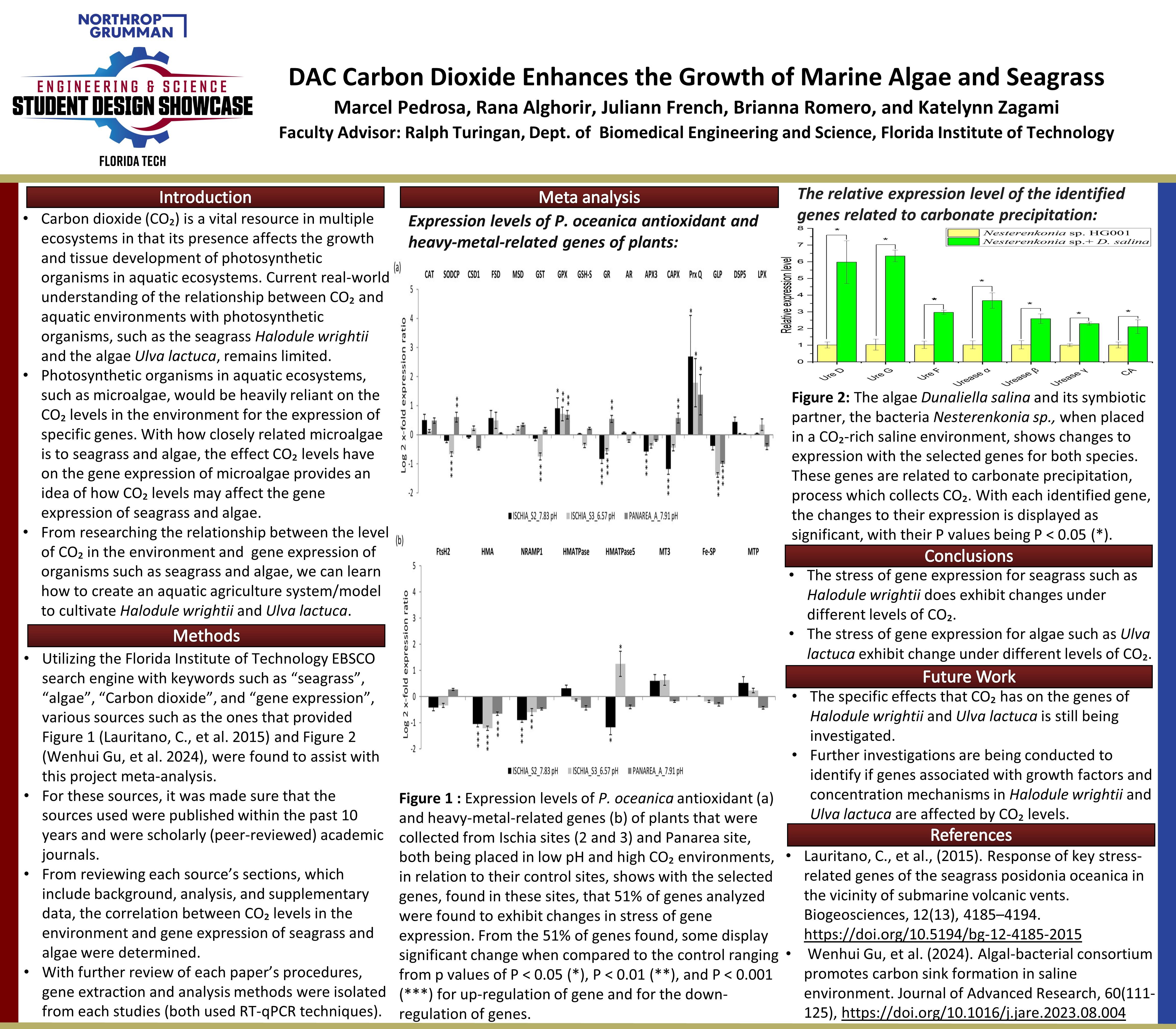
Carbon dioxide is a vital resource in multiple ecosystems in that its presence affects the growth and tissue development of photosynthetic organisms in aquatic ecosystems, and current real-world understanding of the relationship between Carbon dioxide and aquatic environments with photosynthetic organisms, such as the seagrass Halodule wrightii and the algae Ulva lactuca, remains limited. From researching the relationship between the level of Carbon dioxide in the environment and gene expression of organisms such as seagrass and algae, we can learn how to create an aquatic agriculture system/model to cultivate Halodule wrightii and Ulva lactuca.


Project Objective
Our goal is to determine if the different levels of Carbon dioxide effect the stress of gene expression of seagrass and algae.

Manufacturing Design Methods
Utilizing the Florida Institute of Technology EBSCO search engine with keywords such as seagrass, algae, Carbon dioxide, and gene expression, we will find sources to assist with this project meta-analysis. For these sources, they will be made sure to fit the criteria of being published within the past 10 years and be a scholarly (peer-reviewed) academic journal. From reviewing each source’s sections, which include background, analysis, and supplementary data, the correlation between Carbon dioxide levels in the environment and stress of gene expression of seagrass and algae will be determined. With further review of each section’s procedures, gene extraction and analysis methods were extrapolated.


Analysis
When conducting the meta-analysis of Lauritano, C., et al. 2015, and their data on the Expression levels of P. oceanica antioxidant (a) and heavy-metal-related genes (b) of plants that were collected from Ischia sites (2 and 3) and from Panarea, both of which were placed in a low pH and high Carbon dioxide environments, in relation to their control sites, their data showed with the selected genes, found in the Ischia and Panarea sites, 51% of genes analyzed were found to exhibit changes in stress of gene expression. From the 51% of genes found, some display significant change when compared to the control ranging from p values of P

Future Works
The specific effects that Carbon dioxide has on the genes of Halodule wrightii and Ulva lactuca is still being investigated. Further investigations are being conducted to identify if genes associated with growth factors and concentration mechanisms in Halodule wrightii and Ulva lactuca are affected by Carbon dioxide levels.

Other Information
Lauritano, C., Ruocco, M., Dattolo, E., Buia, M. C., Silva, J., Santos, R., Olivé, I., Costa, M. M., & Procaccini, G. (2015). Response of key stress-related genes of the seagrass posidonia oceanica in the vicinity of submarine volcanic vents. Biogeosciences, 12(13), 4185–4194. https://doi.org/10.5194/bg-12-4185-2015 Wenhui Gu, Songcui Wu, Xuehua Liu, Lijun Wang, Xulei Wang, Qi Qiu, & Guangce Wang. (2024). Algal-bacterial consortium promotes carbon sink formation in saline environment. Journal of Advanced Research, 60(111–125), 111–125. https://doi.org/10.1016/j.jare.2023.08.004


Natural Aquaculture Using Technology In Living Underwater Systems (N.A.U.T.I.L.U.S.)


Team Leader(s)
Joe Ciocher

Team Member(s)
Joe Ciocher, CJ Gagni, Martin Pham, Rana Alghorir, Abby Vallejo, Roger Jiang, Will Marble

Faculty Advisor
Dr. Ralph Turingan


Natural Aquaculture Using Technology In Living Underwater Systems (N.A.U.T.I.L.U.S.)  File Download
Project Summary
Our project is trying to find if size of marine protected areas affect the impact that they have on the world around them.


Project Objective
Our goal is to figure out how MPAs can increase the amounts of fish in the ecosystem.

Manufacturing Design Methods
We constructed two tanks: each identical except for scale. These tanks are comprised of various sealants, PVC, paints, and other materials.

Specification
Specifications of this project only include the scale of the tanks.

Analysis
We conducted a meta-analysis of the size distribution of MPAs in the USA and the world, as well as their biological and ecological performance. Results informed the design of an ongoing experiment that investigate the effects of MPA size on its performance.

Future Works
In the future, once these tanks have undergone numerous tests, we will begin to bring the prototypes into the Indian River Lagoon, and other areas of interest.

Other Information
No other information.

Acknowledgement
Joe Ciocher, CJ Gagni, Martin Pham, Rana Alghorir, Abby Vallejo, Roger Jiang, Will Marble, Dr. Ralph Turingan


Effect of Oyster-Shell Orientation on Biomass Accumulation


Team Leader(s)
Robert Bossert

Team Member(s)
Robert Bossert

Faculty Advisor
Dr. Richard Aronson


Effect of Oyster-Shell Orientation on Biomass Accumulation  File Download
Project Summary
My research aims to optimize the efficency of oyster mats by determining if a horizontal or vertical position influneces the recruitment of organisms.


Project Objective
Research Question: Does the orientation of the oyster-shells impact the amount of biomass accumulation on each shell? Hypothesis: Vertically oriented oyster-shells will create a better environment for recruitment like natural oyster reefs because they increase turbulent flow.


Effect of Artificial Lights on IRL Algal Communities


Team Member(s)
Julia Lonks

Faculty Advisor
Dr. Austin Fox


Effect of Artificial Lights on IRL Algal Communities  File Download
Project Summary
Marine phytoplankton are responsible for over 50% of Earth's global photosynthesis, and are vital for carbon drawdown, and form the base of the aquatic food webs. During the daytime, less than ten percent of the sun's energy is converted and available to primary consumers. In the past 150 years, the invention and proliferation of the light bulb have led to abundant artificial light at night (ALAN). All organisms, from humans to phytoplankton, rely on light to control internal biological functions; the most important for this study is the effect of ALAN on photosynthetic activity. As ALAN intensity's extent increases at about two percent per year, understanding the impact of nighttime light on phytoplankton and marine ecosystems is increasingly critical. The increased intensity and varying wavelength of light may impact the extent of artificial light influence on phytoplankton populations in coastal ecosystems.


Project Objective
This study aimed to analyze the effects of different wavelengths of ALAN in the Indian River Lagoon, near the Melbourne Causeway, through laboratory experiments. The expected results were for phytoplankton growth to be greater when exposed to light at night and most significant for purple, orange, and then red. Our objective was to determine the extent that different wavelengths of ALAN impact local phytoplankton communities.

Manufacturing Design Methods
We collected IRL water samples by bucket and transitioned 1500 mL samples into glass jars stored in a water bath by treatment. Four treatments with three sample jars were enclosed in blackout plastic. We attached purple, orange, and red color films to the lights and dimmed the intensity with neutral masking tape to mimic ALAN. The samples were cultured for four weeks in a 12:12 hour light:ALAN cycle. A Sonde YS1 measured DO, pH, salinity, temperature, and chlorophyll concentration. Data points were averaged over five random consecutive points using Google Sheets and Scripts.


Analysis
There was no significant change across treatments and a gradual downward trend over time. We expected there to be a greater chlorophyll content in the tanks with ALAN compared to the dark control; however, the only difference occurred with Site 2; it started at a higher chlorophyll content and had a spike after additional water was added to ensure accurate readings due to evaporation loss. None of the other treatments had a noticeable change, likely because of the lower phytoplankton content. The lack of abundance of phytoplankton in the collected samples and the insignificant effect of ALAN on the surface waters is notable in that lights may not significantly impact marine life due to light attenuation and low incidence of phytoplankton.


Acknowledgement
I would like to thank Dr. Fox and Ben Crews for their help throughout the design and implementation.


Environmental Sciences & Sustainability

Where is the Big Fish?


Team Leader(s)
Declan O'Leary

Team Member(s)
Declan O'Leary, Eddie Wawrzycki-Stein, Michael Kerestes, Regan Shane

Faculty Advisor
Dr. Turingan


Where is the Big Fish?  File Download
Project Summary
Marine protected areas (MPAs) are subsets of traditional fishing grounds that have been closed to fishing as a major component of fisheries management and sustainability programs worldwide. Fish density is higher in MPAs than in Adjacent Fish Reefs (AFRs) and reef-wide fish density is higher in reefs with MPAs. The question this project asks is are fish bigger in MPAs or AFRs?


Biochar Remediation of Regolith Leachate


Team Leader(s)
Mia Markiet

Team Member(s)
Mia Markiet

Faculty Advisor
Dr. Andrew Palmer


Biochar Remediation of Regolith Leachate  File Download
Project Summary
As global populations rise and climate instability worsens, the threat of soil degradation and contamination grows, impacting food security and agricultural sustainability. Over 33% of the world's arable soils are polluted with heavy metals like cadmium (Cd), Chromium (Cr), and arsenic (As), which reduce soil fertility, impair crop growth, and pose risks to human health. Biochar, a carbon-rich product of pyrolyzed organic material, has shown promise on Earth as a soil amendment capable of immobilizing heavy metals and improving soil quality. Its adsorption capacity is influenced by surface area, pore size, and functional groups. Martian regolith simulant mimics contaminated terrestrial soils and gives us a good analog for pollution remediation on Earth and developing extraterrestrial agriculture. This study investigates the effectiveness of pine biochar in adsorbing heavy metals from Exolith™ Martian regolith simulant leachate, for Earth-based remediation and off-planet agriculture. Regolith was leached using 0.5 M HCl to extract bioavailable metals into solution, then treated with 1–20% biochar by volume. Samples were shaken for 72 hours at 25 °C, filtered, and analyzed using Inductively Coupled Plasma Optical Emission Spectrometry (ICP-OES). Z-tests compared treatment groups to the 0% control (p


Effect of Urbanization on Bird Biodiversity in the Indian River Lagoon


Team Member(s)
Brice Smith

Faculty Advisor
Richard Aronson

Secondary Faculty Advisor
Daniel Wagner


Effect of Urbanization on Bird Biodiversity in the Indian River Lagoon  File Download
Project Summary
Birds are bioindicators of ecosystem health, contamination, and climate change. Rapidly increasing urbanization around the Indian River Lagoon, a vital habitat for local and migratory biota, pushes native species into unfavorable habitats and provides opportunities for invasive species. Birds can be assigned three levels depending on their relationship to urbanization: "urban exploiter," "urban adapter," and "urban avoider." I chose one species to represent each of these three categories. Black vultures are urban exploiters, boat-tailed grackles are urban adapters, and limpkins are urban avoiders. I used a Landsat raster from the National Land Cover Database, eBird raw data, and Breeding Bird Survey data to model state-wide population trends, as well as which habitats are affecting species distributions the most in the Indian River Lagoon. I ran regressions to determine the relationship of each species to urbanization. As human population-size increased, the populations of black vultures and limpkins increased (p


Acknowledgement
Special thanks to Robert Bossert for providing artwork.


Mapping the Botanical Gardens: A Guide to Florida Tech's Greenspace


Team Member(s)
Paolo Soto

Faculty Advisor
Dr. Emily Ralston, Dr. Ken Lindeman


Mapping the Botanical Gardens: A Guide to Florida Tech's Greenspace  File Download
Project Summary
The Joy and Gordon Patterson Botanical Gardens on the Florida Tech campus provides recreational green space for students, faculty, and members of the public. It also home to numerous interesting native and non-native plant species. In addition to its aesthetic and recreational qualities, it is also classified as a mixed-woods wetlands by the EPA. By being a wetland positioned at a lower elevation than the rest of campus, the gardens absorb and retain excess rainwater, preventing on campus flooding. All of the positive qualities of the gardens make it an important asset to the university. While there are existing maps of the gardens, they are outdated and don’t give a good idea of what is currently present in the gardens. This project seeks to create a modern map using GIS software that can be used by visitors to locate features of interest in the garden. By filling current information gaps, visitors are able to appreciate more of the gardens. Additionally, spatial data will be essential in guiding efforts to restore or re-vamp areas of the botanical gardens.


Environmental Justice Resource Guide for Melbourne, FL


Team Leader(s)
April Sullins

Team Member(s)
April Sullins

Faculty Advisor
Emily Ralston

Secondary Faculty Advisor
Ken Lindeman


Environmental Justice Resource Guide for Melbourne, FL  File Download
Project Summary
Some neighborhoods in Melbourne, Florida face higher exposure to contaminated soil, industrial pollution, and poor water quality while having less access to green spaces, fresh produce, and reliable infrastructure. These issues often impact underserved communities at a disproportionate rate. There is currently no centralized, accessible platform for Melbourne to learn more about these hazards or respond to them effectively. Therefore, this project had two main objectives: 1. To gather information on environmental justice issues in Melbourne and surrounding areas. 2. Create a guide that equips Melbourne with the context, tools, and resources needed to address environmental justice issues. Local data and mapping tools revealed that over 67,000 Brevard County residents live in highly burdened areas, especially in South Melbourne. These communities face overlapping risks like pollution, flooding, and food insecurity, revealing systemic patterns of inequity across the county. Across Melbourne, and across the world, priority communities continue to face greater environmental risks with fewer resources to advocate for change. With federal policies changing, local and state support for climate action and environmental justice is more necessary than ever. This Environmental Justice Guide serves as a tool for our Melbourne community to empower change for the environment and health of our community. Even in the absence of federal support, informed and organized local communities remain powerful forces for change.


Microplastics Collection in Crane Creek

Project Summary
Microplastics have been found in significant quantities in both freshwater and seawater. Florida's Indian River Lagoon has been the subject of past experiments into the quantities of microplastics in its waters and sediments. Crane Creek, a tributary of the brackish-water Indian River Lagoon is certain to contain microplastics that can be extracted from the surface waters across its 5.3 km length. Various methods can be used to extract these microplastics from the water, including the use of 0.3 mm metal sieves. For this project, samples were taken and then sieved to determine if the locations more downstream Crane Creek would have less microplastics. The locations across Crane Creek where my samples were obtained included the Florida Institute of Technology Campus, a golf course, and the Crane Creek Promenade. Crane Creek flows through the FIT campus, so it was fairly easy to find a location where I could collect samples from. It was important to make sure that each week the three samples obtained from the same location were collected in same section of Crane Creek as before, so to make sure photos were taken of each sample site. The Melbourne golf course close to where samples were also collected was not actively being used, Crane Creek flowed through it near its parking lot. The last location downstream was the Crane Creek Promenade, there was plenty of water available there to sample. To collect these water samples, a standard lab sampling bottle was used. In this case it was a 125 mL LDPE Nalgene bottle, which should not contaminate the samples with any additional microplastics. When taking samples at each of the locations, it is important to fully submerge the bottle so that it is completely filled with water. Three bottles were used per location on Crane Creek so that a significant amount of water was sampled. A 0.3 mm standard testing sieve from the lab was provided to assist in extracting microplastics from my samples. It was well used by with some cleaning it did the task of filtering synthetic plastic particles fine. For the filtering process using the metal sieve, I followed some of the detailed guidelines published by the NOAA. This project wanted to see if it would find more microplastics downstream after the samples were filtered with a sieve. But it turns out that was more plastics in the samples that were further up Crane Creek than downstream at the Crane Creek Promenade.


Acknowledgement
Thanks to Dr. Austin Fox for his helpful guidance and for allowing access to supplies needed for this project.


Meteorology

Analyzing the Cause of Catastrophic Storm Surge during Hurricane Michael (2018) in the Florida Panhandle

Project Summary
This project investigates the primary meteorological drivers of storm surge in the Florida Panhandle during Hurricane Michael (2018), a Category 5 hurricane that caused catastrophic coastal damage. By analyzing ERA-5 reanalysis data and NOAA water level observations, the study identifies strong correlations between wind speed and storm surge, particularly during the hurricane's peak impact period. The results highlight wind speed as the dominant factor influencing water level rise, offering critical insight into the atmospheric-oceanic interactions that drive extreme surge events. These findings aim to inform improved forecasting models and coastal hazard mitigation strategies.


Project Objective
To identify and quantify the relationship between key meteorological variables and storm surge during Hurricane Michael using reanalysis and observational data, with the goal of improving predictive tools for coastal resilience planning and hazard response.


Mechanisms of Twin Cyclones in 2009 Without the Influence of the MJO


Team Leader(s)
Seth Lee

Team Member(s)
Seth Lee

Faculty Advisor
Dr. Pallav Ray


Mechanisms of Twin Cyclones in 2009 Without the Influence of the MJO  File Download
Project Summary
This paper examines a rare twin cyclone occurrence in the Indian Ocean in December of 2009, with special emphasis on determining those processes conducive to development without an active Madden-Julian Oscillation (MJO). Twin cyclones, traditionally symmetric in development in both hemispheres, have been closely associated with an active MJO, which excites convection and equatorial low-level westerlies. The observation indicated, however, that the MJO was not active in this event. Using in-depth analysis, the research discovers that other atmospheric and oceanic circumstances contributed to this singular event. In particular, unusually high sea surface temperature, conducive wind shear patterns, increased low-level vorticity, as well as being affected by moderately El Niño-like circumstances created a thermodynamically favorable setting conducive to cyclone development. Two cyclones were analyzed: Cyclone Ward (North Indian Ocean): It was weaker in intensity and hit Sri Lanka with little damage. Cyclone Cleo (South Indian Ocean): Developed quickly over warm waters, intensified to become the season's strongest cyclone, but stayed at sea with little impact. The studies conclude that even though the MJO is one of the principal causes of twin cyclone events, it is not always necessary. The event in 2009 shows that other non-MJO factors, such as El Niño-related atmospheric changes and sustained SST warming, can also induce twin cyclones. Future studies are urged to analyze other non-MJO twin cyclones to enhance forecasting capacity and understand more complex interactions in the processes of cyclogenesis in the tropics.


Future Works
Future studies will seek to identify other twin cyclone events that happened in the absence of an active MJO to identify whether identical environmental conditions prevailed. This will test whether non-MJO processes such as El Niño, SSTs, and equatorial waves can always precipitate twin cyclone formation. A broader understanding might enhance long-range forecasting and provide insights into tropical cyclone formation in the Indian Ocean.


Acknowledgement
Thank you, Dr. Ray, for assisting me with this project.


Investigating a Concentrated Tornado Outbreak in Southeastern Florida Preceding Hurricane Ian's Direct Impact


Team Leader(s)
Mia Dorval

Team Member(s)
Mia Dorval

Faculty Advisor
Milla Costa

Secondary Faculty Advisor
Melissa Zavaleta


Investigating a Concentrated Tornado Outbreak in Southeastern Florida Preceding Hurricane Ian's Direct Impact  File Download
Project Summary
Present water bodies and atmospheric mechanisms heavily influence the weather phenomena that occur in Florida. One of the most impacted areas includes the East Coast, specifically the southeastern region, as severe thunderstorms and seasonal tropical cyclones frequent this location. In 2022, as Hurricane Ian approached the West Coast, a tornado outbreak produced 14 tornadoes from the Miami area to Delray Beach. Characteristics of this event matched patterns that occur when tropical cyclones approach Florida from the Gulf Coast on a northeastern track, placing South Florida in a highly favorable sector for tornadic events (Hagemeyer, n.d., pp. 1-2). Suggestions of diurnal implications of sea and land surface temperatures on tornado incidents (Hagemeyer, 1997, p.405) from supplementary research showed prevalence in this outbreak as the event occurred between 7 pm (EDT) on September 27th and the following morning at 10 am (EDT) on September 28th. Correlation testing was conducted with ASOS data near KMIA to incorporate reanalysis data from the ECMWF ERA5 collection. The variable investigated was “average monthly precipitation” accrued during 2022. Once completed, additional variables gathered included surface latent heat flux (SLHF), divergence, sea-surface temperatures (SST), and the ‘u’ and ‘v’ wind components. The areas analyzed with reanalysis ranged from 90°W to 75°W and 20°N to 35°N. Skew T’s and reports from the Mesoscale Discussion provided by the Storm Prediction Center explained the energy source for supercell production. Products identified rising warm air and advection of 4.3°C/km to 0.2°C/km from 1-15 km, CAPE of 3285 J/kg, DCAPE of 624 J/kg, CIHN of -6 J/kg, SARS analog of 60% TOR, and LowRH of 87%; reports also showed effective wind shear of 35-50 kt. However, surface observations have limited capabilities and must be corroborated with reanalysis data to fully explain meteorological phenomena at different scales. As a result, an R2 value of 0.873 and a CORREL function value of 0.934 were discovered from correlation testing. The following results were then obtained: SLHF values from -2e06 J/kg to -2.6e06 J/kg, counterclockwise circulation from 0-24 kt at the surface, SST of 304 K (about 88°F), and divergence values from 0.0001s-1 and 0.00025s-1 at 250 mb. The influence of storm tracks and diurnal impacts, previously suggested in prior research, was confirmed, and the importance of divergence was proven. The significance of divergence lies in the understanding that meteorologists often analyze areas of positive vorticity advection and rising air to identify areas of severe weather events. Thus, the values obtained helped demonstrate the favorable conditions that allowed the outbreak, as the locations with the highest calculated divergence coincided with the locations of tornado reports. Intended future analysis will include storm-relative helicity, additional convective parameters, and hodographs.


The “Godzilla” Dust Plume: A Case Study Over San Juan, Puerto Rico


Team Member(s)
Lourdes Duren-Calo

Faculty Advisor
Dr. Milla Costa


The “Godzilla” Dust Plume: A Case Study Over San Juan, Puerto Rico  File Download
Project Summary
The 2020 “Godzilla” Saharan dust plume was one of the most intense Saharan dust events on record, significantly degrading air quality and impacting atmospheric conditions across the Caribbean, including San Juan, Puerto Rico (Pu, B. et al. Jin, Q., 2023). This study investigates the changes in the regional energy budget of San Juan during this dust event using NASA Modern-Era Retrospective Analysis for Research and Applications v2 (MERRA-2) data, Meteorological Aerodrome Report (METAR) observations, Air Quality System (AQS) data, and ECMWF Reanalysis v5 (ERA5) data. By analyzing the downward fluctuations in shortwave and longwave radiation fluxes at the surface, aerosol optical properties, and suspended particulate matter of diameter 10 microns or less (PM10), this research assesses how the “Godzilla” dust plume influenced radiative forcing and meteorological optical range over San Juan, Puerto Rico. The results of this study can help improve climate models, regional weather forecasting, and impact assessments of future extreme dust events.


Case Study: KPHL Visibility in December Causing Aircraft Diversions


Team Leader(s)
Emma Kocsis

Team Member(s)
Emma Kocsis

Faculty Advisor
Dr. Milla Costa

Secondary Faculty Advisor
Nirmal Alex


Case Study: KPHL Visibility in December Causing Aircraft Diversions  File Download
Project Summary
Visibility can decrease when weather such as rain, snow, fog, and mist are present. When visibility deteriorates, pilots and air traffic controller’s encounter operational constraints, leading to aircraft diversions, ground stops, and departure delays. Prolonged low-visibility events increase safety risks for passengers, crew, and aircraft, potentially resulting in collisions. This case study examined the impact of low visibility at Philadelphia International Airport (KPHL) in December 2023, analyzing its effects on arriving and departing flights. Using archived METAR, FAA documentation, and satellite, it was assessed how visibility influences flight diversions and delays. This study presents a time-series analysis of low-visibility events, associated weather conditions, and the total number of affected operations throughout the month. The findings highlight the critical role of weather in air traffic disruptions and emphasize the need for improved operational strategies to mitigate delays and ensure safety.


Manufacturing Design Methods
Archived METARs, satellite images, and FAA data/documentation. The goal was to identify: (i) trends in visibility at or below 2SM for each event (ii) common weather conditions associated with low visibility (iii) evaluate the number of operations effected (delays, ground stops, and diversions) throughout December 2023. (iv) FAA reports to confirm the effects of visibility on arriving and departing flights (v) FAA’s 1-2-3 rule -- Plus or minus one hour of the schedule arrival time, visibility at or below a 2SM, and ceilings at or below 3,000ft.


Analysis
Most events occurred in early morning, 11z (6am EST). The weather event most common was fog with mist coming in as a close second. According to the FAA, KPHL experienced 424 out of 8,474 total operations were affected by low-visibility weather events (approximately 5% of all operations).


Acknowledgement
Thank you, Dr. Costa and Nirmal Alex for supporting me through this project.


Hail Associated with Severe Thunderstorms: Case Study of an Event on April 26, 2023, in Brevard County, FL

Project Summary
Abstract: On April 26, 2023, a severe thunderstorm hit the city of Melbourne in Brevard County, Florida. This thunderstorm produced lots of hail and coated the county and its surrounding areas with hailstones. This study analyzed the conditions of a severe thunderstorm that produced a significant amount of hail in an area of the country that does not often get impacted by hail episodes. The methodology used was reanalysis data from the ECMWF ERA5 Climate Data Store. Observational data was also used, which included Skew-T’s, surface maps, radar imagery, and photo evidence of the event.


The 1998 Central Florida Tornado Outbreak: A Comprehensive Case Study in Tampa, FL


Team Member(s)
Brandan Keen

Faculty Advisor
Dr. Milla Costa, Melissa Zavaleta


The 1998 Central Florida Tornado Outbreak: A Comprehensive Case Study in Tampa, FL  File Download
Project Summary
The 1998 Central Florida Tornado Outbreak was Florida’s most destructive tornado event, spawning three significant F3 tornadoes during the overnight hours of February 22–23. This study investigates the mesoscale and storm-scale processes associated with the outbreak, specifically analyzing the supercell responsible for the Kissimmee tornado. The analysis utilizes NEXRAD WSR-88D Level 2 radar data (KMLB, KTBW) processed in Gibson Ridge Analyst software, atmospheric soundings from the Storm Prediction Center, and topographic relief maps generated in QGIS. Results highlight moderate atmospheric instability, significant vertical wind shear, and potential interactions between severe convection and local terrain Findings emphasize the potential role of the Lake Wales Ridge in modulating storm intensity and supporting tornadogenesis, indicating a potential avenue for future research into topographic influences on severe convective activity in the region


Investigating Sea Breeze Climatology In Tampa, Florida Using Reanalysis Data

Project Summary
The sea breeze forms due to temperature differences between the air over land and the ocean, which affects coastal areas. Within and around Florida, the sea breeze can exhibit complex behavior based on interactions and influences of other phenomena such as El Nino and La Nina, where El Nino and La Nina can shift low-level jet streams, causing years of El Nino to have colder and wetter winters and years of La Nina to have an increase in frequency and intensity of tropical storms in this region. One of the places affected by these mechanisms is Tampa, Florida which is a coastal city in the western central peninsula of Florida. This investigation is centered at the Tampa International Airport (TPA), due to its proximity to the National Weather Service and has the most available data. The methodology and data used for this work were surface observations downloaded from Iowa Environmental Mesonet ASOS from 1990 to 2020, and reanalysis data was downloaded from the ECMWF ERA-5 single-level data set from 1990 to 2020. The variables downloaded from both sources were the two-meter max wind speed and precipitation. To use the entirety of the reanalysis data set, the surface observations and reanalysis data from 2020 were compared along the same time scale to verify the accuracy of the reanalysis data. As a result of that comparison, the correlations of the variables from the reanalysis data downloaded were calculated. NOAA's Oceanic Nino Index (ONI) data was downloaded to compare patterns from 1990-2020. The monthly average variables showed an inversely proportional correlation of 0.482. A focus on the peak wet season was done using the months of July and August from 1990-2020, and the variables' correlation was 0.042. The correlations among the variables proved to be unexpected. However, compared to the ONI patterns, maximums and minimums of wind speed and precipitation seem to match ONI patterns. Years of peak wind speed maximums and peak precipitation maximums were identified, and a possible correlation was found between the years of El Nino and La Nina, respectively. In conclusion, due to the unexpected correlation results, more analysis of the variables involved with the sea breeze, such as temperature and moisture, should be done to create a proper understanding of sea breeze climatology. Future recommendations include adjusting the time scale for daily or hourly data. However, this is only possible if resolutions to the reanalysis data sets can be obtained to combat missing data.


Variations and Inaccuracies in Observational and Reanalysis Atmospheric Water Content Data in Tampa, FL


Team Member(s)
Madisen Alvarez

Faculty Advisor
Dr. Mila Costa

Secondary Faculty Advisor
Melissa Zavaleta


Variations and Inaccuracies in Observational and Reanalysis Atmospheric Water Content Data in Tampa, FL  File Download
Project Summary
Reanalysis datasets serve as essential tools for meteorological research and operational forecasting, providing spatially and temporally consistent representations of atmospheric variables. However, the accurate representation of certain parameters, such as atmospheric water vapor and precipitable water content, remains a significant challenge. These hydrometeorological variables are critical for understanding and predicting severe weather events, yet their complex vertical distribution and dependence on both observational input and model physics complicate their assimilation and reconstruction in reanalysis systems. While observational datasets often reveal coherent signals associated with large-scale climate phenomena such as the El Niño–Southern Oscillation (ENSO), these signals may be underrepresented or distorted in reanalysis products due to limitations in data assimilation techniques, satellite retrieval accuracy, and model parameterizations. This study investigates discrepancies between observational and reanalysis data for atmospheric water vapor and precipitable water content, with the goal of diagnosing sources of error and proposing methodological improvements for future reanalysis development.


Manufacturing Design Methods
The reanalysis data was obtained from the ECMWF ERA5 dataset. The initial parameters requested included hourly minimum and maximum temperatures and hourly relative humidity for the year 2022 in Tampa, Florida. Relative humidity values from ERA5 were analyzed and compared against observational datasets for the same time period to assess the accuracy of the reanalysis. The comparison revealed substantial discrepancies, indicating that ERA5 reanalysis data for relative humidity may not be reliable for the intended analysis. Observational temperature data was sourced from the Iowa State University Mesonet, specifically utilizing ASOS (Automated Surface Observing System) observations for 2022 in Tampa. In addition, a long-term observational dataset of hourly relative humidity from 1960 to 2023 was acquired. Of the 521,526 total hourly data points, 221 were identified as missing. Python was primarily used for scripting automated calculations, handling missing values, and generating comparative metrics, while Excel facilitated initial data inspection, visualization, and organization. Descriptive statistics, including mean values, standard deviation, and other comparative metrics, were calculated to identify anomalies, assess data consistency, and evaluate the reliability of the datasets used for graphical analysis.

Specification
Florida has a unique climate due to its location; hence, Florida is where all of the data in this study is pulled from. An article released by the European Centre for Medium-Range Weather Forecasts (ECMWF) titled “Analysis and forecast impact of humidity observations” talks about variations in observational data. A section of the paper states, “The latent heat release from strong convective events can modify the jet-stream aloft and influence subsequent down-stream developments. The moisture content of the air on the warm side of a frontal zone can influence the rate of development of baroclinic systems. In the tropics, the supply of low-level humidity can affect the intensity of the tropical convection, and hence the intensity of the Hadley circulation” (Andersson et al. 2006). This section highlights three critical factors when reviewing humidity and water vapor content variability. The first point is latent heat release from intense convective events. Hurricanes are significant, intense convective events with high latent heat release. This obviously can increase humidity and significant weather further down in the jet stream, which would explain variants in observational data. The second point is the moisture content influencing the development of baroclinic systems. Atmospheric water vapor content affects temperature in many ways and may have a more significant influence depending on the air pressure. This could explain why reanalysis data showed variation in humidity but not in temperature. The last point brings up an opposite viewpoint on variations in humidity: extreme lows. As mentioned in the excerpt, this low humidity creates trouble for the climate within the Hadley cell, bringing intense weather to the dryer areas and drought to others.


Future Works
Further research and data analysis are needed to identify similar issues in other reanalysis models and observational datasets, and to develop effective solutions. Improvements in the processes used to generate reanalysis data for relative humidity and water vapor content will be essential for these models to be reliably applied in the study of past, present, and future weather phenomena. Satellite data may offer a more accurate means of estimating large-scale total water vapor content and related parameters. Although satellite observations do not extend far into the past, the continuous accumulation of satellite data will enhance the quality of future reanalyses.

Other Information
Featured Image: Comparison of monthly observational and reanalysis relative humidity for Tampa, Florida, 2022. The trends show that the reanalysis ERA5 data was not accurate or precise. The reanalysis data seemed to underestimate the relative humidity for the 2022 calendar year.


Precipitable Water Vapor Trends by Layer Over Florida


Team Member(s)
Deztynee Bryan

Faculty Advisor
Dr. Steven Lazarus


Precipitable Water Vapor Trends by Layer Over Florida  File Download
Project Summary
Precipitable water vapor (PWV) is the total amount of water vapor contained in a vertical column of the atmosphere. The PWV is an indicator of how much water is available for precipitation (Trenberth et al. 2005). Scientists have increasingly studied this parameter to provide insight into extreme precipitation events, atmospheric rivers, tropical cyclones, and climate feedbacks, as PWV is a clear thermodynamic fingerprint of a warming climate (IPCC AR6 2021). This project investigates trends in precipitable water vapor (PWV) over the Florida Peninsula (24°N to 31°N and from -87°W to -79°W) using ERA5 reanalysis from the European Center for Medium-Range Weather Forecasts (ECMWF). Monthly-averaged PWV across all pressure levels was analyzed with a focus on the summer convective season (June–August). The results depict a southeastward shift in PWV maxima toward South Florida, and large anomalies in the midaltitudes. Additionally, PWV systematically increases in the middle and upper layers across all decades analyzed, aligning with the warming trend of regional temperature from the dataset. Notably, the upper layers are moistening with the largest increases in the mid-tropospheric layers (850 hPa - 500 hPa). However, while the lower tropospheric (1000 hPa - 850 hPa) PWV content has increased as well, its percent contribution to the total PWV has declined. This suggests a vertical redistribution of moisture with enhanced mid-to-upper-level moistening. Future work includes investigating the relationship between increased PWV and changes in precipitation intensity and distribution, particularly during extreme rainfall events.


A Case Study: Hurricane Irma’s Forecast Impact on Key West


Team Leader(s)
Austin Portner

Team Member(s)
Austin Portner

Faculty Advisor
Dr. Milla Costa


A Case Study: Hurricane Irma’s Forecast Impact on Key West  File Download
Project Summary
On September 10th, 2017, Florida was in the path of Hurricane Irma which caused significant impacts as it made landfall in the Key West area (NOAA; NHC 2018). The National Hurricane Center (NHC) uses the Saffir-Simpson Scale to measure hurricane wind intensity, making accurate wind data crucial for determining the forecast's precision, with direct implications for preparedness and response. A study by Cangialosi et al. (2021) indicated that NHC intensity forecast errors exceeded the five-year mean at all forecast times. Over the years, in addition to ASOS, ERA-5 reanalysis has served as a complementary source for analyzing hurricane intensity. The aim of this project was to compare wind and temperature data from ERA-5 reanalysis and ASOS observational systems to assess their correlation and impact on forecasting. It is essential to establish a strong correlation between reanalysis and observational data for accurate forecasting. Preliminary tests revealed gaps in the observational data, resulting in a correlation of 52.3% in wind data, and 82.7% for temperature data. The comparison of these correlations highlights the disparity between observational data and ERA-5 reanalysis, particularly in the wind data. Notably, ERA-5 data underrepresented Irma’s intensity, classifying it as a tropical storm rather than a major hurricane. This study identified the potential impact of data quality on hurricane forecasting, emphasizing the critical need for improved reanalysis data to accurately predict tropical cyclone intensity.


Project Objective
The objective of this project was to find where ERA5 reanalysis data could improve in detecting hurricane intensity.


Future Works
Future works include looking at the rapid intensification process of Irma to identify model forecasting gaps and to identify sources of biases in forecast models.


Acknowledgement
Thank you Dr. Milla Costa and Nirmal Alex for guidance in the research and data analysis process.